
Watertown's Two-County ZIP Pair
Official Jefferson County directory material identifies 53094 for Watertown addresses associated with Jefferson County and 53098 for the Dodge County side. USPS material places both in the Watertown postal context. That pairing is the reliable starting point, not a complete street-by-street boundary map.
| ZIP | Verified coverage | Postal context | Records route |
|---|---|---|---|
| 53094 | Watertown postal addresses associated with Jefferson County and the city area | Watertown, Wisconsin label | Confirm with Jefferson parcel search, GIS, clerk, and ward records |
| 53098 | Watertown postal addresses associated with Dodge County delivery | USPS material routes it through the Watertown 53094 processing context | Confirm with Dodge land-information, property, and county records |
No official source in the research set supplied a full neighborhood boundary list, unique institutional ZIP, PO-box-only ZIP, or current per-ZIP population count. The Watertown ZIP code directory therefore keeps the verified county distinction and avoids drawing lines the official sources did not publish.
The city itself sits along the Rock River and covers land in both Jefferson and Dodge Counties. That geography affects the recorder, treasurer, land-information office, clerk, court, and zoning custodian. A five-digit code is useful for sorting a mailing address, but county association must still be tested parcel by parcel near the border. Keep both the postal label and legal jurisdiction in research notes because each answers a different question.
Verify Watertown ZIP Codes with USPS
The USPS ZIP Code Lookup offers three useful paths. Search a full address when the street is known. Search by city and state to see accepted postal relationships. Enter a ZIP to return its associated city names. A standardized result can correct the street form before a county lookup.
| USPS mode | Fields supplied | Best use |
|---|---|---|
| By Address | Company optional; street; city; state; ZIP optional | Standardize one mailing address and detect a mismatch |
| By City & State | City and state | Review the ZIP and city relationship |
| Cities by ZIP | Five-digit ZIP | Find city names associated with a postal code |
USPS warns that its lookup does not confirm a person or company at an address. It is a postal check, not a resident roll. Follow it with GIS and parcel evidence.
The successful manifest capture records the postal search interface. Visit the current USPS lookup before comparing it with the screen below.
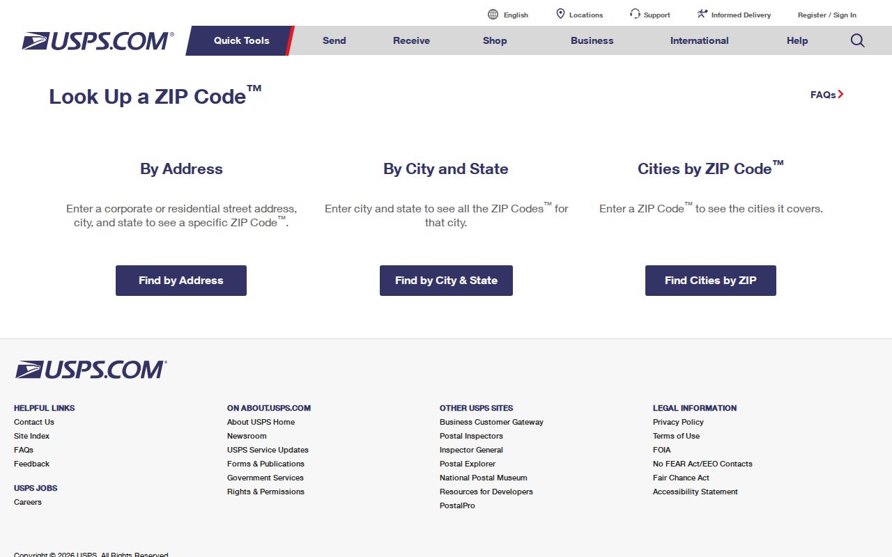
The separate tabs matter because an address check and a cities-by-ZIP check answer different questions.
Find Watertown Residents by ZIP
No verified local portal produces a public, ZIP-wide list of Watertown residents. MyVote accepts a ZIP as one part of a specific address match. Jefferson's parcel search uses address, parcel number, municipality, and township or range details, but no ZIP filter was captured. Dodge County confirms property searching by ID, address, or name, not by ZIP. Use a ZIP code directory to choose a path, not to claim a complete roster.
- Standardize the full address through USPS. Save the five-digit ZIP and exact street form.
- Check the municipal boundary and county annotation in City or county GIS. Decide whether Jefferson or Dodge records control the parcel.
- Search the correct county property tool by address. Compare situs address, mailing address, parcel number, and municipality.
- Use MyVote only for a specific name or address match, or ask the proper clerk about a lawful voter-data request.
- When the goal becomes a named road, continue with the Watertown streets lookup and search individual addresses.
A no-result at one step does not prove that no record exists. Try the other county when the address is near the line, then contact the relevant land-information office if the public tool fails.
Wisconsin's MyVote address mode asks for street, unit, city, and ZIP, then supplies polling and election context for a match. It is not a public block list. BadgerVoters is the separate request route for voter data and can use county, municipality, ward, and other district filters. Confidential electors and protected fields are omitted. Contact the Watertown City Clerk at 920-262-4010 when an address inside the city needs a ward or polling-place check, and identify the election date in any records request.
Watertown 53094 Records Route
For an address associated with Jefferson County, begin with the Jefferson Public Parcel Search. Its address mode separates house prefix, number, half, street direction, street name, and city. A rural prefix or half address can be the difference between a match and a false no-result. The result can show parcel identity, physical or situs address, tax mailing data, valuation, districts, and recorded-transfer links.
Next, compare the parcel with the Jefferson Public GIS Viewer. Its documented layers include addresses, roads, municipal boundaries, annexations, parcels, and county land context. If an instrument or older title is needed, follow the transfer link or contact the Jefferson County Register of Deeds. ZIP 53094 alone does not establish that a city permit or ward record applies.
Note: Treat the parcel's tax mailing address as an owner contact clue, not proof that the owner lives on the site.
Watertown 53098 Records Route
The Dodge side uses a different system. The Dodge County land-information page links its official property search, web map, survey finder, and downloadable data. The county confirms that the property search accepts ID number, address, or name. Exact fields, historic coverage, and a ZIP filter were not captured, so Jefferson controls must not be attributed to Dodge.
Dodge zoning maps identify City of Watertown jurisdiction code 291. County land-information staff at 920-386-3700 can help when a portal session or map does not resolve the jurisdiction. Recorded deeds and older instruments belong with the Dodge County Register of Deeds when the parcel sits on that side. Search each county separately and retain the county name with every result.
Watertown ZIP and City Limits
A ZIP code supports mail delivery. A city limit determines municipal jurisdiction. The City of Watertown warns that a Watertown mailing address may lie outside the city, and a letter-prefixed rural fire number such as W1234 Jones Lane is definitely outside city limits. The Town of Watertown is also a separate Jefferson County municipality.
For a disputed address, compare the USPS result with City GIS, the county annotation, parcel record, legal description, and any annexation document. Use the town or county custodian when GIS places the address beyond the legal city line. This prevents a postal city name from sending a permit, code, court, or ward request to the wrong office.
- ZIP
- A five-digit postal delivery area. It is not a legal city boundary.
- ZIP+4
- An added four digits that narrow delivery to a smaller segment, building, or group of addresses.
- PO-box ZIP
- A ZIP assigned mainly to post-office boxes. No such separate Watertown code was verified in the research.
- Unique ZIP
- A code assigned to one high-volume organization. No Watertown example was confirmed.
- Carrier route
- A postal delivery route within a ZIP, not a public list of residents.
Annexed Watertown Address Records
Annexation can change the office responsible for a parcel while the building stays in place. A 2005 Hady Electric annexation moved land from the Town of Emmet into the City of Watertown. A 2022 boundary adjustment also involved Town of Emmet and Dodge County land under Wis. Stat. §66.0307. The records preserve lot, block, section, and recording details that work better than a postal label.
When a modern address produces no old city result, search its prior town name and legal description. County deeds or tax records may start earlier than city permits, wards, or code files. A ZIP code directory narrows the delivery area, while an annexation ordinance explains the change in municipal custody.
The recorded 2005 annexation is a useful model. Its document identifies the parties and jurisdictions, describes land by lot, block, and section, and carries a Dodge County Register of Deeds document number and recording stamp. Those details bridge the former town record to the later city record without relying on a street number. For similar cases, save the ordinance date and document number, then ask both the old and current custodian which files survive.
Historic Watertown ZIP Geography
Watertown's two-county identity predates modern web portals and postal tools. The 1930 federal census table divided the city's population between Jefferson County, with 7,973 people, and Dodge County, with 2,640, for a total of 10,613. The 1890 table also treated Watertown as a multi-county city and reported 8,755 people in all.
Those figures are historic boundary snapshots, not current ZIP populations. Their value is diagnostic. When a census page, city directory, tax roll, or deed seems to conflict with today's address label, check the county recorded in the older source before blaming an index error. County geography has long shaped Watertown records.
Beyond Watertown ZIP Code Results
A parcel number and legal description are stronger long-term keys than a postal code. Jefferson's sample parcel number is entered as numbers only in its portal, while legal descriptions may use lot and block, subdivision, condominium, section-town-range, or metes-and-bounds language. Do not guess what each digit means without the county key.
City GIS exposes parcel boundaries, addresses, labels, acreage, and Jefferson or Dodge annotations. Jefferson GIS adds municipal boundaries, roads, annexations, plats, and public land layers. These tools connect a street address to the legal record system. Use ZIP 53094 or 53098 to begin, then preserve the parcel ID, county, municipality, and retrieval date with every resident-record note.